Directions
There is something rotten about all the direction software.
How does a pedestrian go from point A to point B? I axed online, and the result sucked something bad… I was at a train station so I went to the train station’s information desk, and axed the official. He checked a similar direction software, and laughed at the result, and said “this is crap, let me tell you how to go there”.
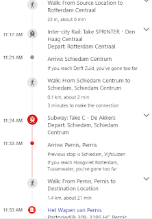
The output was similar to this, but the output the man was looking at was longer, it was like “get on bus, get off bus, walk, get on train” etc. The directions the official had in mind was “get on train D, change to C at X, done”. Only two train lines were necessary, utilizing only one form of transportation.
I can almost see the coding behind these things in my head.. calculating shortest path is one of the oldest problems in computer science. But having a “vertex” for a stop, and an “edge” between two nodes is not enough to compute a route efficiently. Staying on one form of transport needs to be preferred, this would require only a simple weighting change in the optimization. Certain forms of transport also needs to be favored over others, train better than bus (yuck), walking in the beginning and end is okay, but not in the middle, etc. These additions are not that hard.
And please, IT companies, do not let loose some monkey machine learning algorithm on this problem hoping the algorithm will “learn” routes from .. base pixels, people’s movements, or whatever the flunk is the most granular thing with the most available data.. The optimization changes are doable. Code the shit in. TODAY.